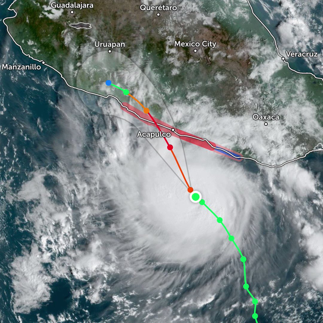
Hurricane Otis, which slammed into the Mexican coast in late October 2023, stands as a stark reminder of the destructive power of tropical cyclones. This Category 5 storm, with sustained winds exceeding 320 kilometers per hour (200 mph), caused widespread devastation, particularly in the states of Guerrero, Michoacán, and Colima.
Otis's Path and Impact

| Date/Time (UTC) | Action | Location |
|---|---|---|
| 23 / 0900 | Tropical Storm Watch issued | Lagunas de Chacahua to Técpan de Galeana |
| 23 / 2100 | Tropical Storm Watch upgraded to Warning | Lagunas de Chacahua to Técpan de Galeana |
| 23 / 2100 | Hurricane Watch issued | Lagunas de Chacahua to Técpan de Galeana |
| 24 / 0900 | Hurricane Warning issued | Punta Maldonado to Zihuatanejo |
| 25 / 0900 | Tropical Storm Warning discontinued | Lagunas de Chacahua to Punta Maldonado |
| 25 / 0900 | Hurricane Watch discontinued | Lagunas de Chacahua to Punta Maldonado |
| 25 / 1500 | Hurricane Warning discontinued | West of Acapulco to Zihuatanejo |
| 25 / 1500 | Hurricane Warning changed to Storm Warning | Punta Maldonado to Acapulco |
| 25 / 2100 | Tropical Storm Warning discontinued | All |
Formation and Early Track
Emerging from a tropical wave in the central Caribbean on Oct15th, 2023, Otis rapidly intensified. By Oct 18th, the National Hurricane Center (NHC) designated it a hurricane, with sustained winds exceeding 74 mph. Its initial track projections indicated a potential brush with the Yucatan Peninsula, prompting warnings across the region.
Unexpected Shift and Intensification
An unexpected shift in wind patterns pushed Otis westward, aiming directly for the Mexican coast. This sudden change caught many by surprise, leaving less time for evacuation and preparation. Over the next two days, Otis underwent explosive intensification, reaching a peak intensity of Category 5 on the Saffir-Simpson Hurricane Wind Scale with sustained winds exceeding 160 mph on Oct 23rd.
Devastating Landfall
On the morning of Oct 24th, 2023, Otis made landfall near the coastal city of Acapulco, Guerrero, Mexico. The storm surge reached a staggering 10 feet in some areas, causing widespread flooding and inundation. Destructive winds exceeding 200 mph ripped through coastal communities, leaving a path of destruction.
winds and pressure
| Date/Time | Source | Wind Speed (kt) | Gust Speed (kt) | Pressure (mb) | Additional Information |
|---|---|---|---|---|---|
| 2320 UTC 24 Oct | ADT data-T numbers | 140 | - | - | Remained above T7.0 through 0510 UTC 25 Oct |
| 0210-0240 UTC 25 Oct | ADT data-T numbers | 158 | - | - | Peaked at T7.6 |
| 0300 UTC 25 Oct | ADT/Dvorak classifications | 145 | - | - | End of historic RI period; strengthened by 90 kt in 21 h |
| 1800 UTC 24 Oct | Aircraft data | 100 | - | - | Major hurricane intensity reached |
| 1603 UTC 24 Oct | ASCAT UHR data | 113-132 | - | - | NOAA/NESDIS STAR analysis |
| 0052 UTC 25 Oct | SAR data | 128 | - | - | |
| Landfall 25 Oct | NHC estimate | 140 | - | 929 | Strongest landfalling hurricane in eastern Pacific basin since 1988 |
| 0640 UTC 25 Oct | Acapulco Port Authority weather station | 99 | 178 | 963.5 | |
| 0645 UTC 25 Oct | Mexican Navy weather station (IRQG3) | 71 | 116 | 957.4 | |
| 0720 UTC 25 Oct | El Veladero National Park (elevated site) | - | 95 | - | 994 ft elevation |
Rainfall and Flooding
| Location | Rainfall (inches) | Rainfall (mm) |
|---|---|---|
| Acapulco | 10.47 | 266.0 |
| El Veladero | 9.82 | 249.4 |
| Tierra Colorada | 8.66 | 220.0 |
| El Dique Pescaditos (Oaxaca) | 5.75 | 146.1 |
| Much of Guerrero | 2–4 | 50–100 |
Impact Assessment

The immediate aftermath of Hurricane Otis was catastrophic. Widespread flooding inundated coastal communities, with reports of vehicles swept away and significant damage to infrastructure. Power outages plunged entire cities into darkness, further hindering rescue efforts. Initial reports indicated 45 confirmed fatalities, with an additional 47 people missing. The economic impact was substantial, with damages estimated in the billions of dollars.
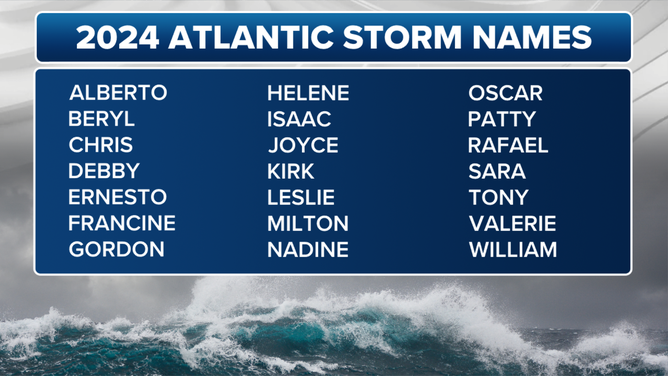
Looking Ahead: 2024 Atlantic Hurricane Season
The season officially begins on June 1, 2024, and ends on November 30, 2024.

The 2024 Atlantic hurricane season is predicted to be above average, with NOAA (National Oceanic and Atmospheric Administration) forecasting 14-21 named storms, of which 6-8 are expected to become hurricanes, including 2-4 major hurricanes (Category 3 or higher). While specific storm tracks are impossible to predict far in advance, it's crucial to stay informed and prepared throughout the season.
how to be prepared:
-
Develop a Family Emergency Plan: Discuss evacuation plans, communication strategies, and designate a meeting place in case of separation. "Ready.gov" offers excellent resources for creating a plan.
-
Assemble an Emergency Kit: Stock up on non-perishable food, water (at least one gallon per person per day for three days), first-aid supplies, medications, flashlights, and a battery-powered radio.
-
Stay Informed: Monitor weather forecasts regularly and pay close attention to hurricane advisories issued by NHC.
-
Know Your Evacuation Zone: Familiarize yourself with your community's evacuation plan and evacuation zone.
-
Consider Flood Insurance: If you live in a flood-prone area, consider purchasing flood insurance for additional protection.
The Importance of Emergency Preparedness

Hurricane Otis served as a stark reminder of the destructive power of tropical cyclones and the importance of preparedness.
Importance of Early Warning Systems: Effective early warning systems played a critical role in evacuating coastal communities and mitigating potential casualties. Continued investment in early warning infrastructure and public education is crucial.
Building Resilience: Strengthening infrastructure, particularly in coastal areas, is essential to withstand the impact of future storms. Implementing building codes and investing in resilient construction can significantly reduce damage.
Preparedness for Secondary Hazards: The risk of landslides and flooding due to heavy rains associated with hurricanes needs to be factored into emergency response plans.
The coordinated effort between the Mexican government, international aid agencies, and local communities proved vital in the aftermath of Hurricane Otis. Strengthening communication channels and fostering collaboration between these entities can ensure a more efficient response in future disasters.
Hurricanes and other disasters can have a significant psychological impact on survivors. Providing mental health services and psychosocial support to affected communities is crucial for long-term recovery.
Hurricane Otis highlights the urgency of addressing climate change. Rising ocean temperatures contribute to stronger and more frequent hurricanes. Long-term solutions require investment in climate adaptation strategies to mitigate the impact of future storms.
Otis Tropical Cyclone Emergency Resources
-
National Oceanic and Atmospheric Administration (NOAA) National Hurricane Center. "Remnants of Otis.".
-
Ready.gov: This government website offers comprehensive hurricane preparedness information, including creating a hurricane plan, building a kit, and staying informed.
-
Federal Emergency Management Agency (FEMA): FEMA offers a wealth of information on disaster preparedness and recovery.
-
Local Emergency Management Agencies (LEMA): Local agencies can offer specific guidance and resources tailored to your community.
- International Federation of Red Cross and Red Crescent Societies (IFRC): "https://go.ifrc.org/emergencies/6726/details" - This link provides details about the emergency response to Hurricane Otis.
-
Direct Relief (2023, October 26). Hurricane Otis, a Rare Category 5 Storm, Slams Mexico's Western Coast [Press release]. from https://www.hotosm.org/projects/hurricane-otis-2023-response
Mental Health and Well-being:
-
SAMHSA Disaster Distress Helpline: Call or text 1-800-985-5990 offers 24/7, free, confidential crisis counseling for individuals experiencing emotional distress related to natural disasters.
-
National Alliance on Mental Illness (NAMI): NAMI provides resources and support groups for individuals coping with mental health challenges in the aftermath of disasters. Call HelpLine at 800-950-6264, text “helpline” to 62640, or chat online. In a crisis, call or text 988
The most popular items on Safecastle


Otis serves as a powerful reminder of the forces of nature and the importance of preparedness. By learning from this devastating event and taking proactive measures


